1.
|

|
Nouvelles
annales de la construction - série des ports de
mer [technical drawing] : docks, bassin Napoléon et avant port
d'Arenc
en construction á Marseille en 1855/ Ingr. Ordre. Mr. Pascal;
Ingr.
en chef Mr. de Montricher; Inspr. General Mr. Busche. - Scales differ.
- Paris : Chez Ver. Dalmont (49 Quai des Augustins), 1855. - 2
technical
drawings on 1 sheet; 37.5 x 55.1 cm OVERSIZE |
2.
|
|
Nouvelles
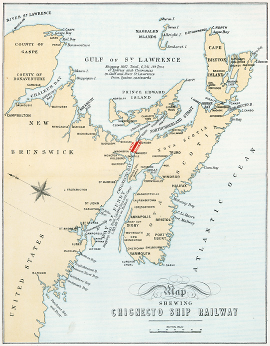
annales de la construction - série des travaux de
fondation [technical drawing] : piles tubulaires en fonte du pont de
Chepstow
sur la Wye et piles tubulaires du pont de Benha/ J. K. Brunel Ingr.;
MM.
R. Stephenson Ingr. - Scales differ. - Paris : Chez Ver. Dalmont (49
Quai
des Augustins), 1855. - 2 technical drawings on 1 sheet; 37.5 x 55.1 cm
OVERSIZE |
3.
|
|
Nouvelles
annales de la construction - série des gares et
stations no. 9 et série des gares et stations no. 10 [technical
drawing] : nouveau système de couverture économique/ par
M. C. Boutillier. - Scales differ. - Paris : Chez Ver. Dalmont (49 Quai
des Augustins), 1855. - 2 technical drawings on 1 sheet; 37.5 x 55.1 cm
OVERSIZE |
4.
|
|
Nouvelles
annales de la construction - série des gares et
stations no. 11 et série des tunnels et souterraines no. 2
[technical
drawing] : maisons de garde et d'inspection et tunnel de Hauenstein. -
Scales differ. - Paris : Chez Ver. Dalmont (49 Quai des Augustins),
1855.
- 2 technical drawings on 1 sheet; 37.5 x 55.1 cm OVERSIZE |
5.
|
|
Nouvelles
annales de la construction - série des machines
outils et série des charpentes et couvertures [technical
drawing]
: nouveau tour á roues de wagons et marquises économiques
á serrage variable/ Ingénieur M. C. Boutillier. - Scales
differ. - Paris : Chez Ver. Dalmont (49 Quai des Augustins), 1855. - 2
technical drawings on 1 sheet; 37.5 x 55.1 cm OVERSIZE |
6.
|
|
Plan
of survey for the water supply to the city of Fredericton N.
B. from Tower Lake [cartographic material] : section of route for pipes
from lake/ by C. C. Gregory, C. E. - Scale 1 in. to 825 ft; vertical
scale
1 in. to 80 ft. - 15 January 1867. - 1 profile : pencil and ink, on
tracing
paper, col.; 73.7 x 125.7 cm OVERSIZE |
7.
|
|
Public
Works Canada - Wellington Harbour - Lake Ontario-Ont. [technical
drawing]/ E. G. S. - Scales differ. - [18-?]. - 6 diagrams on 1 sheet :
pencil and ink, on tracing paper, col.; 62.2 x 99.1 cm OVERSIZE |
8.
|
|
Public
Works Canada - proposed extension of pier - Cobourg Ont. [technical
drawing]/ U. V. Delt. - Scales differ. - [18-?]. - 12 diagrams on 1
sheet
: pencil and ink, on tracing paper, col.; 62.7 x 83.8 cm OVERSIZE |
9.
|
|
Section
of Mill Creek Valley [cartographic material]. - Scales 1
in. to 300 ft. and 1 in. to 20 ft. - [18-?]. - 14 diagrams on 1 sheet :
pencil and ink, on tracing paper, col.; 113 x 64.8 cm OVERSIZE |
10.
|
|
Public
Works Canada - extension of breakwater at Wood Islands, P.
E. Island [technical drawing]. - Scales differ. - [18-?]. - 12 diagrams
on 1 sheet : pencil and ink, on tracing paper, col.; 69.9 x 104.1 cm
Note: Panel title: Public Works Canada - extension of breakwater at
Wood Islands, P. E. Island OVERSIZE |
11.
|
|
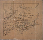
Portions
of Victoria, Northumberland and Restigouche Counties [cartographic
material]. - Scale 1 in. to 100 chains. - [18-?]. - 1 map : pencil and
ink, on tracing paper, col.; 59.7 x 52.6 cm OVERSIZE |
12.
|
|
General
map to accompany report on the Intercolonial Railway exploratory
survey of 1864 [cartographic material] : made under construction from
the
Canadian Government/ by Sandford Fleming, C. E.. - Scale 3 cm to 10
English
statute miles. - Montreal: Burland, Lafricain & Co., 1864. - 1 map,
81.8 x 143.4 cm OVERSIZE |
13.
|
|
Approximate
profile Intercl Rlwy [Intercolonial Railway] exploratory
survey of 1864 from R Trois Pistoles to R Snellier [cartographic
material]/
by Sandford Fleming. - Scale 1 in. equals 500 ft. Vertical scale 1 in.
equals 50 ft. - Traced 1864. - 1 profile : ink; roll 48 x 4 cm in
diam. OVERSIZE |
14.
|
|
Approximate
profile Intercolonial Railway exploratory survey of
1864 from River Snellier to Green River [cartographic material]. -
Scale
1 in. equals 500 ft. Vertical scale 1 in. equals 50 ft. - Traced in
1864.
- 1 profile : ink; roll 48 x 10 cm in diam. OVERSIZE |
15.
|
|
City
of Fredericton [cartographic material]: showing streets from
riverfront to Charlotte St. and from Smyth St. to Sunbury St. - Scale 1
in. to 100 chains. - [187-?]. - 1 map : pencil and ink, on tracing
paper,
col.; 68.6 x 238.8 cm OVERSIZE |
16.
|
|
City
of Fredericton [cartographic material] : showing area from
riverfront to eleventh range at Maryland lots and from Mill Creek to
Kingsclear
grant as well as the area of watershed to Maryland Road. - Scale 1 in.
to 10 chains. - [187-?]. - 1 map : ink, on tracing paper, col.; 36.5 x
73.7 cm OVERSIZE |
17.
|
Selection
of Maps
|
Chignecto
Marine Transport Railway plans [cartographic material]
[New Brunswick and Nova Scotia]/ H. G. C. Ketchum and Charles J.
Townshend.
- Scale 1 in. equals 800 ft. - September 1885. - 4 maps on 4 sheets :
col.;
roll 65 x 10 cm in diam. OVERSIZE |
18.
|
|
Map
showing Chignecto Ship Railway [cartographic material] : [New
Brunswick]. - Scale 1 in. equals 30 nautical miles. - London (London
Wall)
: Waterlow & Sons Limited, [188-?].- 4 maps on 4 sheets : col.; 42
x 37.5 cm
Note: Includes sketches showing ship being raised on lift, ship lifted
ready for transit, and ship in transit. - 2 maps are located in OVERSIZE |
19.
|
|
Interior
of cold house with ice chamber and refrigerator chamber
for [Chignecto Ship Railway?] [architectural drawing]. - [188-?]. - 1
architectural
drawing; 65 x 98 cm OVERSIZE |
20.
|
|
Exterior
of cold house for [Chignecto Ship Railway?] [architectural
drawing]. - [188-?]. - 1 architectural drawing; 45 x 98 cm OVERSIZE |
21.
|
|
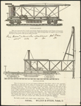
Plates
of leader and smokestack and railroad pile driver [technical
drawing]. - Toledo : Wilcox & Stock, [188-?]. - 2 diagrams on 1
sheet;
32 x 25 cm
Note: Diagrams were published in printed form |
22.
|
|
Plates
of Osgood steam shovel and Victor steam shovel [technical
drawing]. - [188-?]. - 2 diagrams on 2 sheets; 15 x 21.5 cm and 14.5 x
25.5 cm
Note: Diagrams were published in printed form |
23.
|
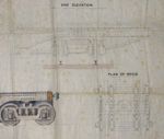
Selection
of
Drawings
|
Chignecto
Marine Transport Railway [technical drawing] : cross section
of ship carriage and plan of bogie. - [189-?]. - 4 diagrams on 1 sheet
: pencil and ink, on tracing paper, col.; 66.5 x 186.7 cm OVERSIZE |
24.
|
Selection
of Drawings
|
Chignecto
Marine Transport Railway [technical drawing] : traverser,
carriage, carriage chamber. - Scale 1/2 in. to 1 ft. and 1/4 in. to 1
ft.
- [189-?]. - 5 diagrams on 1 sheet : pencil and ink, on tracing paper,
col.; 66 x 186.7 cm OVERSIZE |
25.
|
|
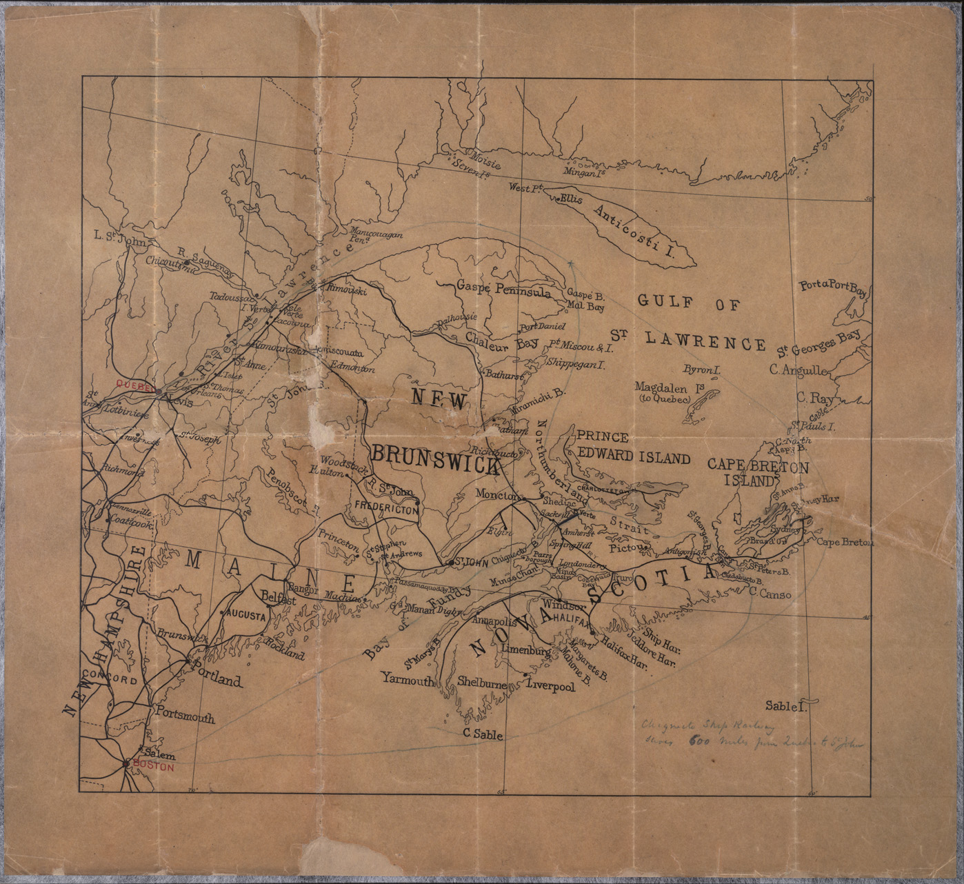
Maritime
Provinces and eastern Maine [cartographic material]. -
[189-?]. - 1 map on 1 sheet; 44.5 x 49 cm. - scotch tape holding map
together
in 2 places
Note: Pencilled note on bottom right "Chignecto Ship Railway saves
600 miles from Quebec to St. John" OVERSIZE |
26.
|
|
Chignecto
Marine Transport Railway [technical drawing] : marking plan of
gridirons/ H. - 27 March 1890. - 3 diagrams on 1 sheet : ink, on
tracing paper; 78.7 x 173.9 cm OVERSIZE |
27.
|
Selection
of Drawings
|
Chignecto
Marine Transport Railway [technical drawing] : Amherst
Basin and terminus. - Scale 1 in. to 8 ft. and 1/2 in. to 1 ft. - 7
July
1990. - 9 diagrams on 1 sheet of tracing paper : pencil and ink, on
tracing
paper, col; 95.3 x 186.7 cm OVERSIZE |
28.
|
|
Sault
Ste. Marie Canal [technical drawing] : plan showing outline
plan, filling and emptying culverts, longitudinal section &/ T.
Trudeau.
- Scale 1 in. to 20 ft. - 5 April 1892. - 1 diagram; 57.2 x 166.2 cm OVERSIZE |